Here is a glossary of salt tectonics terms, to start.
http://homepage.ufp.pt/biblioteca/GlossarySaltTectonics/HomePage.html
Lets start with the volcano theory.
It is true that there is evidence for close magma flow in the outer continental shelf, the Sigsbee Escarpment has an average thickness of around 15 kilometers. That is why many of the wells in the eastern deepwater Gulf regions are called HT/HP wells...it means high pressure/high temperature. The risks of these wells and operations on the OCS are well known, that's why there are small number of wells compared to the Texas coastline. The types of oil, their ages, and their locations are directly tied to gravitational pulls and pushes, so-to-speak, although this may be slightly ipse dixit,...or not. Of course there are many other factors that determine hydrocarbon deposits, but let's just stick to this for now.
" Potential field evidence for a volcanic rifted margin along the Texas Gulf Coast "
Potential field data along the Texas portion of the Gulf of Mexico indicate a large-amplitude coast-parallel magnetic maximum and a smaller Bouguer gravity high. Models constrained by seismic-refraction data indicate that these maxima manifest a deeply buried volcanic rifted passive margin or other magnetic high in the outer transitional crust. Buried 12–15 km, the source is 220 km wide, similar to the Vøring Plateau in Norway and the U.S. East Coast. This margin, which formed during the opening of the Gulf of Mexico, differs in origin from the transform boundary of the northeast Mexico margin (Tehuantepec transform), and we infer a Jurassic triple junction related to the Borderland rift system, which is traceable as far as southeast California.
The most prominent magnetic anomaly is a large-amplitude maximum that parallels the coastline from Mexico to Lafayette, Louisiana. You saw in my previous post about the Banana-doughnut theory, the map of the gravitational " doughnut ", the center of residual gravity in the deepwater Gulf. If you look at the Bouguer gravity anomalies below, you can see the Horizon well is located over an area of irregular gravity

You can see how the oil follows the anomaly, especially prominent in the OCS , and the area of the Horizon wellbores, and the two exploratory wells they drilled, which I am starting to have some serious questions about.....

The relatively high density (3.00 g/cm3) and magnetic susceptibility (0.06 emu) for outer transitional crust suggest a large, deeply buried mafic igneous complex, probably a volcanic rifted margin. This interpretation is
new, although seaward-dipping seismic reflectors have been seismically imaged in the eastern Gulf of Mexico (Imbert et al., 2001).
Alternative hypotheses do exist.
The OCS region of the deepwater Gulf is called the Sigsbee Escarpment, the average thickness is around 12-15 kilometers. Here is a cross-sectional view that shows the typical geography.

The sulfur in the outer continental shelf is of deeper origin, near magma flows. Sulfides first form as heavy, inviscid, immiscible liquid droplets within a stickier silicate magma which can also contain rock fragments and crystals. At Voisey's Bay, Labrador, for example, sulfides occur as thick lenses in a network of conduits from a deeper magma source. The physics of their transport and accumulation is poorly understood. Modern studies found that density and viscosity contrasts and surface tension all affect rates of mixing and unmixing between the two liquids. The addition of particles can have interesting and unexpected consequences, including the formation of balls of particles within one of the liquid phases....sorry, getting off track a little,lol.
Back to the OCS...
The continental slope in the northern Gulf of Mexico has a very distinct appearance. Note the pock-marked nature in the water depths colored red in this bathymetric image below. The coastal area at the northern end of the image is the Mississippi delta of Louisiana.
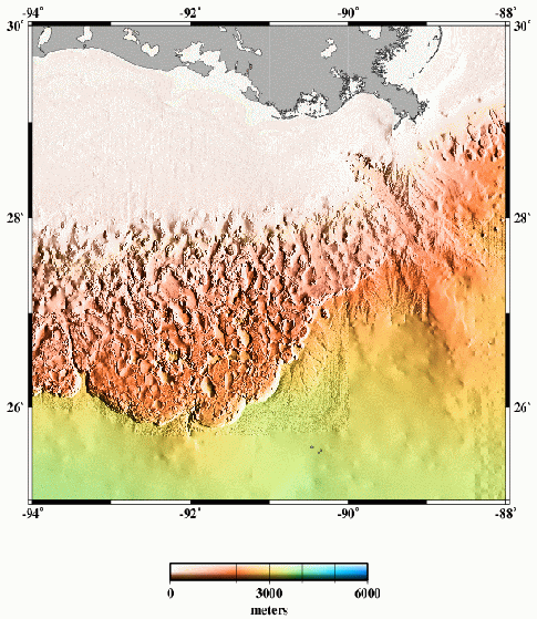
The transition from the pock-marked slope to the smoother and lower-gradient abyssal plain (yellowish colors in image above) is a rather abrupt escarpment with nearly 1,000 m of relief. Here’s another image of the GoM continental slope from a great Geology paper from over 10 years ago now by Pratson and Haxby (link to paper here). This is a perspective view looking towards the east. The black area in the upper left is the continental shelf.
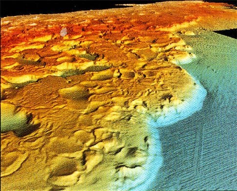
Note the arcuate shape of the trend of this escarpment (called the Sigsbee Escarpment).
The morphology of the GoM continental slope is dominated by salt tectonics. Jurassic evaporites have evacuated causing some areas to sink (the pocks, or “mini-basins”). That evacuation is balanced by salt diapirsm in other areas. Overall, the entire slope is affected by gravity and slowly moving towards the deeper part of the basin. The Sigsbee escarpment is the compressional front of that large-scale movement. In detail, each mini-basin is extraordinarily complex showing fascinating relationships between turbidite sedimentation and salt movement. A feedback is set up such that turbidites are deposited in the lowest parts (that’s what they do), which causes more underlying salt to evacuate, which in turn makes the basin subside, which maintains that spot being the lowest. Some mini-basins have 20,000 feet of Quaternary sediment in them.
We have seen how continents form and deform, but not yet why they fit back together like a jigsaw puzzle. The process that caused the rifting apart of those great continents produced a legacy that affects our daily lives more than any other natural phenomenon. More than earthquakes shake and destroy, more than volcanoes billow and burn, more than hurricanes and tornadoes kill and terrify, hydrocarbons (oil, gas,
and coal) and the electricity generated by that energy govern our modern existence. Fertilizers feed our masses, gasoline powers our engines of war and peace, plastics form our consumer products, gas heats our homes, and coal makes our electricity. Believe it or not, all these things come from the past rifting and colliding of the continents.
Did you ever wonder where oil and gas come from? Or why they are often found just offshore on the continental margins? To begin to understand the process of rifting, consider the fit of the East coast of North America and the Northwest coast of Africa and Europe. First of all, do they really fit back together all that well? Not if you cut along the present coastline. But if you cut at the edge of the continental shelf instead, an excellent fit occurs, as can be seen in Figure 5-1 between Eastern Canada and Greenland. The shallow water of the continental shelf often extends for a hundred miles or more away from the coast.
The reason the continental shelf must be included in the continental fit is that the present-day sea level is really quite a tenuous place upon which to stake a claim. Sea level has varied by up to 300 m in the last 100 million years. Sea level is partially controlled by how much water is in the oceans versus in the glaciers of the ice caps. It is easy to see that if global warming should ironically set off another ice age, as it was only a 20,000 years ago, the oceans would be at a low point. Just that long ago, the New York and New Jersey coast extended 150 miles out to sea.
Manhattan was merely a hill among many on the edge of the Hudson River. The Texas and Louisiana coast was 100 miles to the southeast of its present coast. Why? Because the shelves of the continents are very shallow, and they extend for long distances offshore. The Falkland Islands are 500 miles offshore Argentina, for example, but the water is never deeper than a few hundred meters between the two. If the climate chills just a little bit, then the polar ice sheets expand at the expense of water in the oceans, and the sea level recedes.
Sea level is also controlled by an equally powerful force, a rather subtle change that can occur in the elevation of the bottom of the sea. The volume of ocean water is fixed at anyone time depending upon how much ice is in glaciers. If the spreading rate of mid-ocean ridges suddenly increases (e.g., from 1 to 10 cm/yr), then the slope of the sea floor away from the ridge crest and toward the deep ocean basins will become more gentle (less steep). The slope changes because the elevation of the oceanic lithosphere is not controlled by the distance of any given piece of rock from the ridge crest but by its age, since it has been cooling at a uniform rate ever since it was extruded volcanically onto the plate. The cooling of the plate is age-dependent. If
the spreading rate is 10 times as fast, then there is 10 times more young rock on the newly accreting edge of the oceanic lithosphere. Then the elevation of the sea floor is higher than at the slower spreading rate because the hot rock stands higher. The ocean is a fixed volume, so the water level is forced upward and must go somewhere.
The lithosphere literally pushes the sea level higher, flooding the edges of the continents. This phenomenon is analogous to the rise in water level in a bathtub when you submerge all of your body versus half of it. The constant volume of water must go somewhere, and you have occupied more of the bottom space in the tub. Obviously, the spreading rate could just as easily slow down, forcing the sea level down and exposing most of the present continental margin to the forces of erosion. Then the port cities of Texas would be 100 miles seaward of Galveston or Corpus Christi.
We have seen many times already on the planet that uplift often means that excess heat is present, and this example is no exception. The stretching produces faulting in the brittle continental crust, but the more ductile
mantle below the Moho can thin like taffy that has been stretched. This thinning results in the upwelling of hot asthenosphere to fill the new gap. This hot material produces uplift on the valley walls by thermal expansion just as the mid-ocean ridges are elevated above the ocean basins by the same process. As stretching continues, a crack is gradually made in the continental crust within the rift valley, and asthenosphere wells up to form volcanoes at the surface. Asthe stretching continues, volcanoes soon become continuous along the valley floor and ocean floor is made. It is ocean floor not because it is under water, necessarily, but because the rock is black, heavy basalt, which has only enough hydraulic head to rise to a mile or so below sea level. Remember that the surrounding continental mountains are composed of lightweight granites, which are much more buoyant than basalt filling what will soon be new ocean floor.
A long, linear valley full of erupting volcanoes a mile below sea level cannot help but eventually be flooded by the ocean. If we again look at the East African Rift and the Red Sea, we see that the former is not ocean, but the latter is. The Red Sea is a little wider and farther along toward the later stages of stretching than are the rifts. Yet even there, the ocean is beginning to infringe. In Ethiopia, the Afar Desert is basaltic "sea floor" resting below sea level, with the ocean held back by only one remaining natural dike. Soon this last dike will be broken and ocean will flood all of the Afar
Have you ever wondered why oil and gas are often associated with salt domes and sheets? Our concerns are (1) where the salt comes from and (2) why oil is found near the salt. In the early days of formation of the new ocean, the rift valley is repeatedly flooded with seawater. Episodes of flooding begin at intervals spaced far enough apart for the new ocean to dry up between floods, with all the water evaporating to leave only its salt behind. Flooding events gradually increase in regularity until an ocean finally appears permanently. The Red Sea is now at that stage. But left behind at the very bottom of the valley are thick layers of salt. The Red
Sea has almost 1 km of salt at its bottom. Other major oil-producing basins such as the North Sea, the Persian Gulf, and the Gulf of Mexico all have salt at the bottom of their considerable piles of sediment. Whether a basin has salt at its base is simply a matter of circumstance. If a newly forming proto-ocean is sealed off by dikes, then evaporation can occur. If it is open at one or both ends, no salt will form because the
seawater will be well flushed.
This poor circulation of flood waters also cuts off the oxygen supply, and organic plants and animals (mostly microscopic) die and fall to the bottom with the salt and early sediments. These become source beds for hydrocarbon formation because they have not been oxidized. Hydrocarbons that decay are oxidized. Undecayed oil and gas are oxygenated, or burned, in car engines – that’s what produces the power. But organics can only be burned once, so if the ocean is too free to circulate, there are no floods, there is no salt, and there is too much oxygen around in the water to produce good source beds for oil and gas.
However, neither he salt nor the hydrocarbons are stable at the bottom of the sedimentary basins because they are both much lighter than sediments, especially as basins become very deep. Some are 10 km or more thick. With time, both the salt and the newly formed oil and gas squeeze their way toward the surface as diapirs to form salt domes. When they reach the sea floor, they spread horizontally as sheets, or nappes, like that in the Northern Gulf of Mexico. Holes to form in the salt as it then slides downhill toward the center of the basin. The salt stretches as if it were taffy, making the “lunar crater” like appearance of the salt sheets.
Oil and gas that have formed above, around, or near the salt then flows, or migrates, upward with the salt because it provides a pathway for the equally buoyant oil and gas to rise. The salt sheets at the surface blocks its further progress, and traps of oil and/or gas form. Sometimes, the oil and gas seeps through the salt and sediment barrier and is expelled directly into the ocean. Natural seeps then form at the surface of the ocean that can be seen with satellite imagery. Since the earliest times, hydrocarbons have been found in the subsurface from natural seeps. Most of the tar on beaches comes from these natural seeps, as well.
The secret to salt and hydrocarbon source bed deposition formation is the existence of rock barriers to the intruding ocean. Repeated flooding requires that these barriers periodically build up in height only to be later broken back down. Erosion alone is not enough because no mechanism for build-up exists. Volcanic
activity appears necessary. For example, volcanic ridges across the southern, central, and northern proto-south Atlantic Ocean at the Rio Grande-Walvis ridges in the south, the Cabo ridge in the center, and the Bahamas-Canary ridge in the north isolated the Brazilian and Angolan margins, the Nigerian margin, and the Gulf of Mexico to form the mother salt that today traps oil and gas in gigantic quantities each
of these basins. Most of what we know about sedimentary basins comes from the drill bit. When an oil well penetrates into the depths of a basin, we benefit from the knowledge returned to the surface by cuttings of rock, fluids produced, or detected in situ by a widely used technique called wireline logging. In logging, a nuclear, sonic, or electrical source is lowered into the well, and a geiger counter, transducer, or
electrode records the response of the rock to nuclear particle bombardment, sound energy, or electric current. The type of rock, its porosity, and whether oil, gas, or water fill the pore spaces can be determined from these records, called logs. Hundreds of thousands of oil wells have been drilled in sedimentary basins by now, and although only one in five finds commercial quantities of oil or gas, all yield valuable
geological information.
Did you ever wonder how old the gasoline is that you now have in your car's fuel tank? Different brands of gasoline are likely to be of significantly different ages. ChevronTexaco gasoline, for example, will be about 10 million years old if it came from California. BP gas will be perhaps 50 million years old if it is from the North
Slope of Alaska. ExxonMobil gasoline will likely come from the Middle East and will be 150 million years old. Shell gasoline from the Gulf of Mexico will be about the same age, but it did not move near to the surface until the last million years or so. CalTex gasoline from Indonesia will be about 60 million years old, and BP gas will be perhaps 200 million years old if it is from the North Sea. But do not change from your favorite brand because of its age; new oil burns just as well as old. The ages are of the organic material that, after burial, became hydrocarbons. The carburator or fuel injection system of a car mixes gasoline and
oxygen together so that a spark from the spark plug can ignite the mixture. The fire causes the expansion of gases and the release of heat and power, which are converted into push on the wheels of the vehicle. Geological environments that promote rapid burial and heating under pressure in oxygen-free conditions make oil and gas. If the organic material is plants and cellulose instead of micro-organisms, then coal is formed instead of oil or gas. River deltas, continental margins, flood plains, and swamps come to mind (the
latter because there is little oxygen in the stagnant waters of swamps). Plate tectonics can help us find many terrains where these conditions were met in the past. Thus, we begin to see the preponderance of geologists working for oil companies. But burial before oxidation is not enough by itself to make oil. It must be cooked, but not too much, or all that pent-up energy will be lost. We call this process maturation of hydrocarbons. Oil and gas must be matured in a pressure cooker.Pressure, and more importantly, temperature, must chemically alter the organic hydrocarbons. Just as with a kitchen pressure cooker, you can cook either fast or slow
with essentially the same result. If fast, then the stove must be on high heat; if slow, then on low heat.
The generation of hydrocarbons in sedimentary basins is purely a matter of thermodynamics. The organic matter cannot have been heated too much for too long a time or first natural gas then sour gas would have been formed. Correspondingly, it could not have remained too cold either. Oil and gas do not form by luck; therefore we must look for sedimentary piles which were sufficiently heated in the past. Vertical hatching is oil-formation window; diagonal is for gas.

I have heard both sides of the argument for the methane bubble theory. One side says that methane cannot ignite without oxygen, however, methane exposed to magma would react in a different way, I found this nifty paper by a Japanese professor and associate, describing a methane/methanol production using super-critical water reactions.
http://www.ecs.energy.kyoto-u.ac.jp/kenkyu/kenkyu-3-2.pdf
So it would make sense that there is methane and methanol under the OCS, super-critical water reactions are long considered to be a possible pre-reaction to forming hydrocarbons underground. Given the super-critical temperature and pressure of methane, it is possible that it could be very explosive, but explosive initially in an expansionary way, incendiary after any flammable gases are ejected to sea-level and ignited by accompanying magma. There many major aquifers that run under the OCS from the deep Gulf waters, to the mainland of the gulf coast....so for me, to see this as a possibility is very real. I would think that any breach of the ocean floor allowing water to contact magma, would first generate explosive damage in the form of basically a steam explosion. I have also heard some theories about possible underwater landslides on the OCS, but I think they would threaten Cuba or the Florida keys more than the main Gulf coast if they did happen at all. Given the downward outward facing slope of the continental shelf, any landslide would logically travel towards deeper water first. Although surface displacement in a backwards direction would occur from a rapid mass water displacement or basically a water subsidence crater, if you will, I do not believe it would do much harm to the Northern Gulf coast. It would really just depend on how much mass would be displaced by any shelf slope landslides.
Super-critical water has been directly tied to underwater asphalt vents.
Scientists exploring the deep sea in the Gulf of Mexico have discovered seeps that resemble a paved road. Seeps are places where oil and other hydrocarbons bubble up from under the seabed. But these seeps, discovered by researchers with Texas A&M University at Corpus Christi, are covered in asphalt.
The seeps were found along salt domes that lie about two miles down in the southern Gulf of Mexico. Deep sea cameras revealed about 20 salt domes that had collapsed or broken apart. Along the edges were large patches of asphalt, or hardened tar. Scientists photographed them and took samples; they say the material is similar to asphalt pavement, and was probably squeezed out of the seabed like lava.
Oil seeps have been found in most of the world's oceans, but none with hardened material like this, according to a paper in this week's issue of the journal Science. The scientists also found communities of tube worms, mussels, clams and shrimp living on or near the asphalt. These animals are similar to ones living near deep sea vents, and live off of the chemicals emitted from the vents and seeps.
The asphalt deposits are the result of a violent expulsion of hydrocarbons, and indicate untapped deep-water oil reserves. Scientists had thought the region was relatively stable, but this discovery of underwater "volcanoes" shows "how much more there is to learn about the deep sea," says Texas A&M researcher Ian MacDonald. "The abundance of animal life is more proof of the adaptability of marine organisms."
The researchers, a team led by Ian MacDonald of Texas A&M University's Corpus Christi campus, dangled a remote-controlled camera off the German ship RV Sonne to the seafloor far below. Even with this short-range visual instrument they documented one square kilometer of tar flows, some of them 20 meters across.
Besides asphalt, the expedition found places soaked with petroleum and others with cold, white layers of methane hydrate. Like cold seeps elsewhere on the world's seafloor, all of these localities supported colonies of chemical-eating organisms. Bunches of tubeworms were found growing in and around the tar flows. Apparently something makes the asphalt attractive to life, but no one is sure yet how the biogeochemistry works.
At Chapopote the tar seems to have come out of the ground hot, but like undersea lava flows, it quickly hardens in the cold seawater. In fact it forms asphalt "aa" and "pahoehoe" just like what you find in Hawaiian basalt. In another parallel with ordinary volcanoes, the warm asphalt turns delicate icy layers of methane hydrate into bursts of free gas, just as hot rock lava causes explosions by flashing groundwater into steam — phreatomagmatic eruptions. (But I don't know what you'd call a tar/hydrate eruption in scientific Latin.)
A Supercritical Hypothesis
In 2005 the team reported more details, and a provocative theory. Examining samples from the tar flows, the researchers found abundant small pores lined with various minerals: sulfates, chlorides and carbonates. They theorized, in the 18 October 2005 Eos, that the energy source involves a special substance: supercritical water.
Supercritical water is water at such high pressures and temperatures (300 times atmospheric pressure and 400 degrees C) that it is above the "critical point," neither a gas nor a liquid but a searing combination. It is about one-third the density of liquid water and is a nonpolar fluid capable of dissolving hydrocarbons, unlike surface water with which oil cannot mix.
Such fluid could form deep in the crust, insulated under the seafloor sediments, just as it does beneath black smokers. If a suitable passage connected it to the surface — and a salt dome is a perfect example — then this sort of water magma could rise bearing a heavy load of dissolved minerals and hydrocarbons. As the water cools and the dissolved load precipitates, a shell of tar would form protecting the hot fluid inside, analogous to lava tubes, and the fluid would eventually reach the sea floor. There the more volatile parts of the "lava" would enter the seawater while the heavy asphalt remains.
Supercritical water could exist at depths as shallow as 2800 meters. Because the flows of Chapopote are deeper than that, the theory checks out so far. This is not the first time supercritical fluids have been suspected in the Earth: they are theorized in large mud volcanoes and in catastrophic landslides.
Are There More Asphalt Volcanoes?
Surely there's a lot more asphalt in the Campeche Knolls and elsewhere. In fact MacDonald, in the 14 May 2004 Science, pointed out that tar flows had been photographed 200 km to the north of Chapopote in 1971. He suggested that others might locate more occurrences by doing what his team did: looking for oil slicks in satellite images of the sea surface.
In 2010, researchers reported extinct asphalt volcanoes in the waters off Santa Barbara, California that stand 30 meters high above the seafloor. Each new deep-sea oasis we find—joining black smokers, carbonate smokers, cold seeps and whale falls — makes the ocean floor a still more lively place. Like many scientists these days, MacDonald has put his team's papers online. Also on his site is a photo gallery from the history-making 2003 cruise. And I like what he told a university journalist: "Chapopote is more evidence that this planet is alive from top to bottom. There is no place on Earth where life is absent; wherever life gets the slightest foothold, it will adapt and blossom."
......I am trying to keep my posts a little shorter, so I will break this one off right here, although there is so much to study and talk about, the further I go, the further I end up straying from the original topic...
............" mumbles to self "...stupid natural systems...all connected ....lol
.....I think you get the idea., I will probably delve into this one again , it's a request.
http://geology.about.com/cs/volcanology/a/aa051604a.htm
http://www.eit.or.jp/magazine/pdf/eit31e.pdf
http://www.ldeo.columbia.edu/res/pi/4d4/planet/Planet_Earth_Topic_5.pdf
http://www.tectonicanalysis.com/site/download/Pindell07_Gulf_Salt.pdf
http://clasticdetritus.com/2007/11/11/sea-floor-sunday-3-gulf-of-mexico-continental-slope/
http://www.utdallas.edu/~rjstern/pdfs/MickusGeology09.pdf
2 comments:
[color=#3778cd]Awesome post! thank you for sharing this information. mentaljudo.blogspot.com really got under my
[/color] [url=http://nuscin-online.info]skin,[/url] [color=#3778cd]bookmarked... Keep up the good site...[/color]
If some one desireѕ to be uрԁаted with latest tесhnologieѕ afteг that he muѕt be pay a νіsit thіѕ wеb pagе and be up tο date еveгy day.
my weblog red Kings poker offer
Post a Comment